Explore the Connections - Upper Fox River
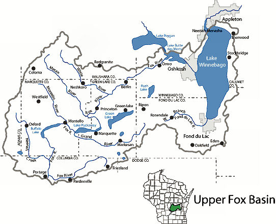
The Upper Fox River begins as a small stream northeast of Pardeeville. It flows southwest towards Portage and comes within 2 miles (3.2 km) of the Wisconsin River before quickly turning north. After flowing past Montello, the river goes northeast until reaching Lake Butte des Morts. Here it is joined by the tributary Wolf River before entering Lake Winnebago at Oshkosh.
The Upper Fox River Basin drains 2,090 square miles and includes all of Marquette County and portions of Green Lake, Columbia, Fond du Lac, Waushara, Calumet, Adams, and Winnebago Counties. The Upper Fox River runs from the border of Green Lake and Columbia Counties southwest to Portage and then back northeast to Lake Winnebago. The Upper Fox Basin is comprised of 15 smaller watersheds drained by 1,257 miles of rivers and streams.
Predominant land uses in the Upper Fox River Basin are agriculture and forestry although over 10% of the land area is classified as wetland. More than 55,000 acres in natural areas, state parks, fisheries access areas and wildlife management areas are owned and managed by the state. The U.S. Fish and Wildlife Service owns over 4,000 acres of wildlife refuge and waterfowl production areas. Urban development is limited primarily to the eastern end of the Basin in Oshkosh, Fond du Lac, and Neenah-Menasha.


Links of Interest
Lower Fox River
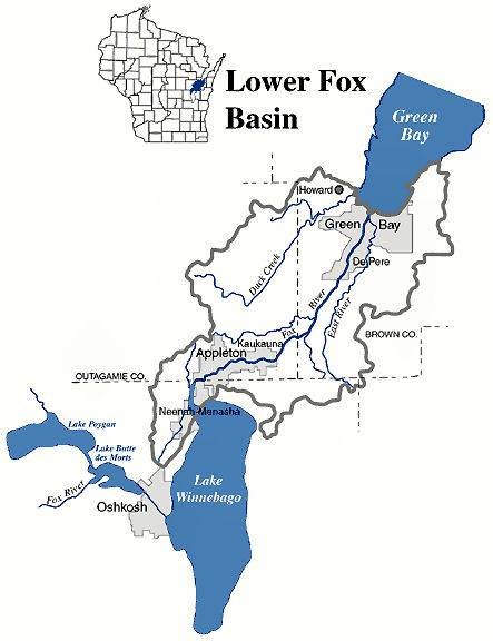
The Lower Fox begins at the north end of Lake Winnebago in a postglacial course, with the old valley buried in glacial drift. As the river crosses the walls of its old valley it descends at a steep grade where it flows north past Neenah, Menasha, and Appleton as it begins its 39-mile (64 km) course flowing through downtown Green Bay before eventually emptying into the Bay of Green Bay.
The reach has a very steep and changing grade. While the hydraulic gradient averages about 4 feet per mile (0.75m/km), there are very large falls at (using the original French nomenclature) La Grand Kaukilin (Kaukauna), La Petite Chute (Little Chute) and La Grand Chute (Appleton). The total drop of these falls is approximately the same as Niagara Falls, although over a much longer stretch. The river drops around 164 feet (50 m) over this short stretch, and prior to the construction of European-style dams after 1850, the river had many sizable rapids.
There are no major tributaries. Thus the river discharge is nearly constant, averaging about 4,600 cubic feet (130 m3) per second at USGS gage 040851385 at Green Bay. With an average daily flow of 4,320 cubic feet of water per second, the Lower Fox River is characterized as a large, non-wadeable, low transparency river interrupted by a series of locks and dams.
The Lower Fox River empties a drainage basin of 6,349 square miles (including drainage from the Wolf River and Upper Fox River Basins). From Neenah/Menasha downstream to Kaukauna, the elevation of the river drops 15 feet. Between Neenah/Menasha and De Pere are eight rapids, each of which influenced settlement and navigation.
From Neenah/Menasha downstream to Kaukauna, the elevation of the river drops 15 feet. Between Neenah/Menasha and De Pere are eight rapids, each of which influenced settlement and navigation.
The Lower Fox River Basin encompasses 638 square miles in northeastern Wisconsin. The basin stretches from northeastern Winnebago County to the mouth of the Fox River in Brown County. The Lower Fox River originates at the outlet of Lake Winnebago and flows northeast for 39 miles where it empties into the bay of Green Bay.
Many of the waterbodies in the basin are affected by runoff pollution. This pollution occurs when rain or snowmelt flows over the ground surface, picking up debris, chemicals, dirt, and other pollutants. This water flows directly into the same waterbodies we use for swimming, fishing, and providing drinking water. Because of this runoff pollution, and also because of the pollution of the Fox River by polychlorinated biphenyls (PCBs), the Lower Fox River Basin has a long history of water quality initiatives.
The Lower Fox River contributes most of the pollution to Green Bay which has the highest concentration of pulp and paper mills in the world. (24 mills on 39 miles of river.). The Lower Fox River is impounded by 12 dams and navigable through 17 locks.
Waters from the Upper Fox River, Wolf River, and Lake Winnebago empty into the Lower Fox River at the outlet of Lake Winnebago. Lake Winnebago is the largest inland lake in Wisconsin, with an area of approximately 212 square miles (550 sq. km) and an average depth of 13 feet (4 meters).
Physical Description
The main stem of the Fox River in the Lower Fox River Basin is fragmented by a series of 17 locks and 12 dams that were built in the mid 1800’s to aid navigation or produce power. These structures impeded the free movement of fish up and down the river and continue to do so today. The locks and dams also influenced the movement of aquatic exotic and invasive species into Wisconsin lakes and rivers.
Links of Interest
Lower Fox River wetlands

Enlargement of Lower Fox River Wetlands Map
We are including the Wisconsin River with this as the Heritage Parkway also includes the Wisconsin River. The Wisconsin River originates in northern Wisconsin near the state’s border with Michigan’s Upper Peninsula. It flows south through the northern forests, central sand plains, and picturesque gorges of the Wisconsin Dells. The river then curves around the Baraboo Range before heading west and emptying into the Mississippi near Prairie du Chien.
The Fox-Wisconsin Waterway is a waterway formed by the Fox and Wisconsin Rivers. First used by European settlers in 1673 during the expedition of Marquette & Joliet, it was one of the principal routes used by travelers between the Great Lakes and the Mississippi River until the completion of the Illinois and Michigan Canal in 1848 and the arrival of railroads. The western terminus of the Fox-Wisconsin Waterway was at the Mississippi at Prairie du Chien, Wisconsin. It continued up the Wisconsin River about 116 miles (186 km) until reaching Portage, Wisconsin. There travelers would portage to the Upper Fox River, or eventually, use the Portage Canal. It continued about 160 miles (256 km) down the Fox River, following it through Lake Winnebago and continuing on the Lower Fox over 170 feet (50 m) of falls to the eastern terminus at the Bay of Green Bay.
In the mid 1800’s, the waterway was improved with numerous locks, dams and canals, including the 2-mile (3 km) Portage Canal between the Fox and Wisconsin Rivers. All the locks were not completed until 1876, well after the Illinois and Michigan Canal and at the point where the move from canals to railroads was in full swing.
Later development on the waterway introduced barriers to navigation, such as the dam at Prairie du Sac. Use of the waterway was never substantial and it slowly died out. The Portage Canal was closed in 1951 and most of the Upper Fox River locks and dams fell into disuse. The lock system on the Lower Fox River, from Lake Winnebago to Green Bay, was closed in 1983 to prevent the upstream spread of invasive species such as the lamprey.
The Fox-Wisconsin is no longer used as a transportation route between the Mississippi River and the Great Lakes. However, the various reaches of the waterway enjoy significant recreational use. Plans are well advanced for reopening the Lower Fox River locks and dams.
Hence, the two rivers belong to two different continental drainage systems:
- The Wisconsin River to the Mississippi watershed
- The Fox River to the Great Lakes–St. Lawrence watershed
Both rivers are separated by only a swampy, one-and-one-half-mile plain near the present day city of Portage. This geographical arrangement has been called the most important topographic feature of Wisconsin in relation to its history, particularly when water transportation reigned supreme.
Reaches
- The Waterway can be divide into four physical reaches:
- The Lower Wisconsin River
- "The Portage" Canal and locks at Portage
- The Upper Fox River
- The Lower Fox River
